 |
Mexico to Lake Mead on Backroads--Arizona | |
|
Mexico to Lake Mead on Backroads--Arizona | |
In late 2002, I began to search out a route from the Mexican border northward that would travel on back roads and avoid pavement driving as much as possible. I had done an east west route from California to New Mexico in 2000-2001 that crossed the state on less than two miles of pavement driving. When I finally drove that route from beginning to end, it took me five very long days and was over 500 miles in length. I was hoping to do something similar with this new route.
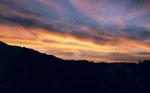
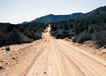
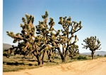
Since I was pretty unfamiliar with the far western part of the state, that is where I went exploring. It took several trips to put the route together. This is what I found. I have not driven the entire route in one session yet, but hope to do so very soon. The roads vary from good graded County Roads to rough doubletracks that require 4wd. There is quite a lot to see along this route from old military stuff to mining relicts. For you desert rats you will be right at home.
The description is very general at this time. When I finally drive the route in one stretch, I'll produce a more detailed description as I did previously. Generally, there are several ways to get from point to point. If interested, use the Delorme Arizona Atlas and Gazatteer to follow along. However, not all the roads that I'll describe show up in that book.
A. The Border to Interstate 8:(pages 62,63)
The route starts at Border Monument 193 on the border south of Yuma Arizona. This monument is west of the Tinajas Altas Mountains. There are several monuments that you can choose from. We came down the west side of the Gila Mountains from Yuma. Moving to the northeast to start the route, we crossed through the Tinajas Altas Pass, then headed for the Copper Mountains where we turned eastward through a break in the Mohawk Mountains to the San Cristobal Valley. We went north down the San Cristobal Valley to the old military base at Stovall. From there we turned west along a rough frontage road that parallels the railroad tracks to the Mohawk Interchange on I-8. There is a gate in the fence that allowed us to cross under the interstate and head northward on Ave 52 1/2 East.
 |
 |
 |
B. InterState 8 to Interstate 10:(pages 62,55)
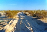
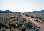
Fom I-8, we worked our way northeastward on farm roads past the obvious volcanic hill in the distance called Texas Hill to the Hyder Road which parallels a set of railroad tracks. We turned west until we came to a large rock monument describing the training efforts of General Patton in this section of the desert. We turned north and worked along the edges of several farm fields until we intercepted the road shown in the atlas that passes through the Palomas Mountains. This road deteriorates to a rough doubletrack as it leaves the mountains. Once in the Palomas Plain, which contains outstanding Sonoran Desert growth we headed for the four way intersection shown northeastwardly on Hoodoo Wash. At that intersection I have gone two directions northward--to the right is the Palomas Harquahala Road to the left is the rougher Hovatter Road. We cross I-10 at Exit 53. There is nothing at that exit. There is a gas station at exit 45.
 |
 |
C. Interstate 10 to Salome(pages 55,47)
The road northward from I-10 is a good graded country road that passes the cemetary and mine at Harquahala. Gas can be obtained at Salome.
 |
 |
D. Salome to I-40 (pages 47,46,37,36)
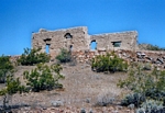
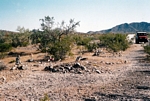
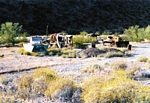
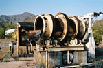
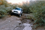
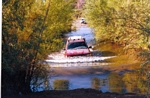
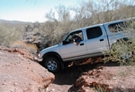
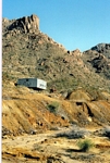
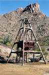
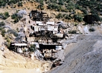
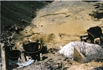
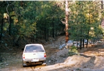
We headed north out of Salome and then west along the southern edge of the Granite Mountains. There are two very rough passes through the heart of these mountains, but I haven't driven them. We hit the Yuma Mine Road and passed by the jojoba orchards at McVay. We then turned north to the Butler Valley Area and then a rode a bit further north to the Transmission Line Road. It was then westward to Midway and then north on the Lincoln Ranch Road. To this point on the route, there have usually been options on roads to travel. The next objective is to cross the Bill Williams River. As far as I know there is only one ford. That is at a point on the river so that when you cross you pass between the Swansea Wilderness and the Rawhide Mountains Wilderness. That ford is accessible by a gasline road that crosses the Lincoln Ranch Road. Once across the river, you can continue on the gasline to the Alamo Crossing Road out to Yucca on I-40 or you can take a rougher road as a slight detour around Potts Mountain to the Alamo Crossing Road. Once on the Alamo Crossing Road we headed west to the Boriana Mine Road which turns north through the Hualapai Mountains. This road passes by the Antler Mine and the Boriana Mines which were very large operations in their day. The Boriana Road deteriorates to a narrow shelf road that requires 4wd in seveal spots. Once in the pines, we turned to the right and worked our way down off the mountain to the good graded Blake Road that runs out to a truck stop at exit 66 on I-40.
 |
 |
 |
 |
 |
 |
 |
 |
 |
 |
 |
 |
Blake Road to Lake Mead(pages37,29,28)
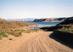
After refueling at the truck stop at exit 66, we continued eastward on the north side of I-40 to a powerline road. We then traveled north on that powerline for several miles and then diverted to the east to the dirt Hackberry Road. At Hackberry we turned back onto the powerline road and crossed Highway 66 near Antares. We made our way on an obscure road to the Antares Road which took us north to the Pierce Ferry Road. The road to Gregg's Landing carried us on the final leg to Lake Mead. Earlier, on the Antares road, we could have diverted from traveling to Lake Mead and instead could have climbed up on the rim of the Grand Wash Cliffs and driven Buck and Doe Road out to overlook the Grand Canyon or we could have turned east and driven to the bottom of the Grand Canyon at Peach Springs. So the route could just as well be "From Mexico to the Grand Canyon".
 |
 |
 |
 |
| Trips |
| Home |