 |
The
Roosevelt Power Canal and Diversion Dam, Gila County, Arizona-
Then and Now
|
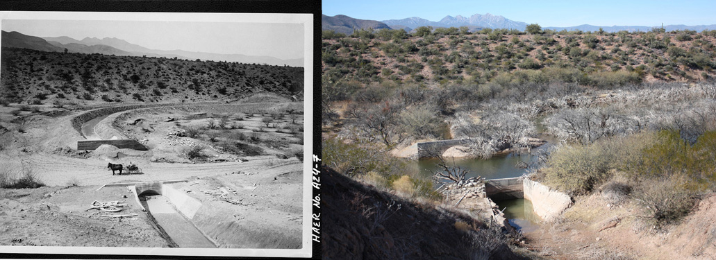
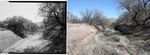
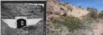
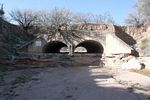
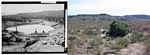
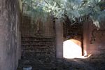
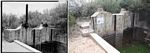
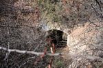
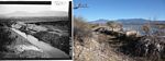
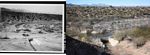
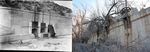
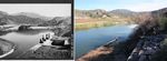
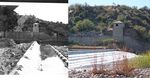
Pressure Pipe/Cut and Cover structure on the Power Canal at School House Wash as seen in 1906 and in 2011
The nearly 20 mile long Roosevelt Power Canal and Diversion Dam were constructed in the years 1904-1906 to divert water from the Salt River to a hydroelectric generating plant that would provide the power to run the machinery used in the construction of Theodore Roosevelt Dam. That project was the federal government's first involvement with reclamation projects in the Southwest.
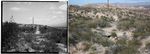
I became interested in the story of the Power Canal after a camping/paddling trip to Roosevelt Lake. My wife and I had come across one of the old arch culverts associated with the Power Canal system. A subsequent online search turned up the HAER(Historic American Engineering Record) report on the Power Canal and Diversion Dam. This report, published in 1985, included a detailed accounting of the construction and operation of the two components, vintage photographs, and historical maps.
After reading the report, I thought that I would like to try to find as many of the structures that had appeared in the HAER photographs as I could. It was an interesting, and challenging, process to re-locate the structures. Very few of the photos had any written clues as to their location. The use of the report's listing of structures and its maps, in conjunction with Google Earth photos got me started. I walked to most of the features, driving to a few. The great majority could actually have been accessed by boat at the January 2011 lake levels(90% full, 8' below maximum). As to be expected, there have been a lot of changes to the structures since 1904-1906. I was quite surprised at the some of the dramatic changes that have occurred since 1984, the dates on a few of the photographs contained in the report. Unfortunately, below Mile Marker 7(somewhere near the School House Boat Ramp), quite a few of the sections of the canal are currently underwater or have only recently re-emerged. The majority of the canal's structures from Mile 7 onward have either disappeared, or have been severely compromised. That is too bad--some of the best of the original photographs are of structures located downstream from Mile marker 7. I did not venture below Mile 13, near the Windy Hill Campground after I found the entire area of the canal located there underwater.
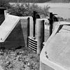
In the search for the structures that were the subjects of the HAER photos, I came across many other structures that had not been recorded. Many of those were good examples of the original Power Canal features and I have included their photos here.
A Very Brief History of the Power Canal
The Power Canal/Diversion Dam system went into operation in 1906 and remained active after the completion of the Roosevelt project in 1911. The original plans for the big dam had not included a way to use reservoir water to generate electricity! That was corrected in 1916.
In the decades that followed, the Power Canal was brought back on line whenever the lake level would drop too low for water to enter through the dam. It was last used from 1946-1952 and was officially retired in March of 1952 after a particularly heavy rainy season refilled the lake. In 1972, the penstock tunnel at the mouth of the canal was filled with concrete. That meant that the canal was permanently disconnected from the power generating equipment.
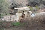
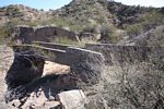
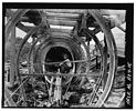
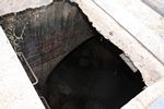
The Power Canal was constructed first. Its overall length was 19.3 miles and had a grade of 30' to the mile. With a base width of 8', the canal was designed to carry water to a depth of 4.5'. There were 152 numbered structures constructed along the canal. These included a variety of culverts, cut and covers, concrete and wooden flumes, and pressure pipes(inverted siphons), whose main purpose was to carry the canal water over or under cross-running washes. The largest of these structures were the Pinto Pressure Pipes that ran for 2600' under Pinto Creek.
There were also 20 tunnels constructed to get the water through the intervening hills and ridges. The longest of the tunnels was the 1625' long Intake Tunnel. It ran from the intake gates at the Diversion Dam westward under the surface to the first open air section of the canal.
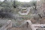
Several sets of overflow weirs and sluice gates(flood gates) allowed the operators to control the level of water in the canal. Originally, the system was operated by three persons--a gate operator at the dam who controlled the intake gates, and two ditchriders who did the routine maintenance on the canal. The ditchriders lived out on the canal--one near Pinto Creek and the other at Cottonwood Canyon.
The canal was a dirt canal and was only concreted in problem areas where the sidewall materials were very soft and crumbly or the harder materials were too porous. The longest stretch of lined canal was in the last mile or so before the Roosevelt Dam site.
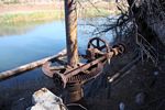
The system did not work flawlessly. The Diversion Dam washed out in 1916 and was not replaced until 1937. Temporary brush and rock dams were used in the intervening years to divert water into the input gates. The canal also required re-habilitation over the years--tunnels had to be re-built, sections of canal had to be cemented, many of the wooden structures had to be repaired or replaced, and hundreds of thousands of cubic yards of silt had to be removed.
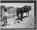
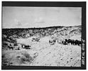
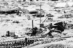
There is no "heavy" equipment to be seen in the construction photos of the Canal. The excavation of the canal seems to have been done with horse or mule teams pulling small scrapers. There are no clues as to how the concrete was prepared for the culverts or the lining of the canal. It would have been interesting to have seen how the concrete was mixed. Were there mixing machines of some type used, or was the job done by a bunch of guys with shovels? A friend of mine noted that the aggregate in the concrete was not crushed rock but screened river run. That meant that the strength of the concrete would not have been particularly high.
|
 |
The Photos of the Power Canal
I have arranged the photos in order from the output portal of the Intake Tunnel. That was the starting point for the Power Canal or Mile Marker 0. The first listing for each photo is the official designator from the HAER maps. The number is the mileage segment. The letter indicates the position of the structure relative to the mile marker. For example, 4A is the 1st structure below mile marker 4. 10C would be the third structure below mile marker 10.
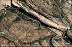
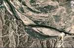
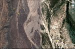
The first photo below is a Google Earth capture of the first section of the Power Canal west of the Diversion Dam. I have placemarked four of the first five numbered structures located on the canal. Access to the Diversion Dam is from Highway 288, the Young Highway.
Click on Photos to Enlarge: (All Black and White Photos are from the HAER Report)
 |
 |
 |
 |
 |
A dirt road to Roosevelt Lake Estates parallels the second mile of the canal.
 |
 |
 |
 |
 |
At the point the Roosevelt Lake Estates road crosses the canal west of Eads Wash, a very short spur road brings one to the Wherli Cut-Off. The Canal seems to split into two directions. In fact, it did. Flooding of the Salt River in 1905 brought on a relocation of 2500' feet of the canal to the west. Several new tunnels and other structures were required to accomplish the new placement of the canal.The "cut-off" section of the canal branches to the left and seems to end at a blank hillside. Careful examination of the loose rocks will reveal the concrete foundation of the first tunnel that carried the canal's water through the hill. If you climb to the ridgeline you will get a view to the north of a concrete flume and several of the other tunnels that made up the cut-off.
The original canal passes through the "no vehicles beyond this point" sign. From there out to the set of sluice gates and weir it is a very pleasant walk of about 1.5 miles.
 |
 |
 |
 |
|
 |
 |
 |
 |
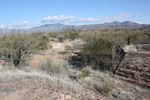 |
Vehicular access can be made to mileage segments 4 and 5 on an obscure road down a sand wash. The road is FS 397. The level of the lake in January of 2011 was quite high and access on the normal route to the Pinto Settling Basin was blocked by high water. I walked in from a little more than a mile to the east of the basin. The easiest travel is up the bottom of the canal. The sidewalls are very heavily vegetated with mesquite and catclaw. It is apparently a popular route for ATV's and the bottom is very clear.
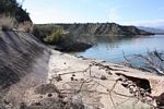
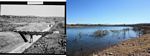
The large basin on the east bank of Pinto Creek was a settling pond. Silt was supposed to separate from the canal water before it entered the Pinto Pressure pipes. These pipes were the first large diameter, long length, re-enforced concrete pipes ever used. Normally, pipes of such diameters(5') were made of wood or iron.The two pipes were cast in place. A special metal form was created by the engineers on the project. The form traveled on a track and was dragged forward as needed. The two pipes were 2600' in length. Current Google Earth photos show a portion of the western end of the pipes exposed--that is when the lake is much lower than current conditions.
 |
 |
 |
 |
|
 |
 |
 |
 |
 |
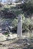
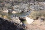
Mile marker 6 was originally posted in the center of Pinto Creek. Access to the structures west of Pinto Creek is now best accomplished from the road to the School House Campground. The hillsides, and the canal itself, are pretty densely populated with mesquite and catclaw growth. So travel carefully!
 |
 |
 |
 |
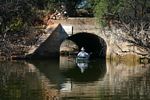 |
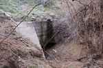
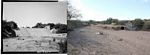
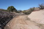
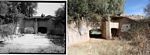
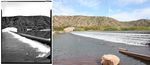
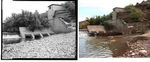
West of the School House Boat Ramp, the travel along the Power Canal was also pretty difficult. And the views of its associated structures were also pretty disappointing. I did walk approximately a mile downstream, but gave it up when I did not see very much. I did want to see if my luck would be better if I skipped over to Mileage segments 10 and 11 west of Grapevine. The vintage photos from the HAER report of the weir and sluice gates, and the cut and cover at School House Wash were pretty neat. I was anxious to see how conditions today compared. I accessed those segments by walking west from the parking lot near the Grapevine parking lot. A dirt road drops off the side of the hill down to the canal which is currently at the very edge of the lake. My last stop in the Power Canal part of the project was a section of the canal located at the new Windy Point Campground.
 |
 |
 |
 |
 |
 |
 |
 |
A Brief History of the Diversion Dam
The construction of the Diversion Dam began after the completion of the Power Canal. There were two reasons given:
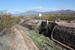
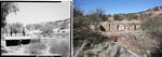
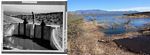
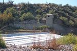
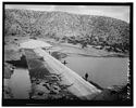
The site for the dam was selected so that once the reservoir filled and backed up the river channel, the dam would not be inundated. Its construction was of concrete and boulders and was not attached to the bed rock but sat on the boulders, gravel, sand and silt that made up the river channel. The south end of the dam butted against a bluff at the edge of the river channel and extended 400' to the north. The dam was constructed to a height of 7'. It was intended for floodwaters to pass over the dam--hopefully with little damage. A cement apron extended out a short distance from the base of the dam to help guard against undercutting. Three intake gates were installed in the south wall of the dam. A long intake tunnel constructed into the bluff connected those gates to the Power Canal. The gates were 7' wide and 5' wide. They were hand operated.
As described above, the dam washed out in January of 1916, with 200 feet of its length destroyed. Sections were actually moved several feet downstream. In the 1930's, it was decided to re-build the Diversion Dam and discontinue the use of the temporary brush and rock structures that been used since 1916. The new dam was essentially a duplication of the first one in that its profile remained the same. Its length was extended 85'. Riprap boulders were put in above and below the dam. A wider apron was installed and dentated sills were added out on the apron to diffuse the force of the overflow. There were other modifications made to the equipment at the dam. The hand operated gate lifting mechanisms were replaced with electrically operated ones. A heavy flood nearly washed out the rebuilt dam the day after it was officially declared restored. Repairs included the installation of rock-filled wire baskets into the large hole created by the flood. The apron was also extended further out.
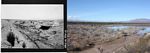
After the Diversion Dam/Power Canal system was retired in 1952, it essentially sat until 1989. At that time modifications were made to the dam's profile. It appears that some of the sluice openings may have been sealed. A plaque on the north abutment states that the modifications were done to improve safety issues. The purpose of the dam today is to act as a fish barrier to prevent the migration of fish up into the Salt River Channel.
The Photos of the Diversion Dam
 |
 |
 |
 |
 |
 |
 |
 |
 |
 |
 |
 |
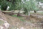
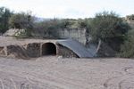
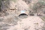
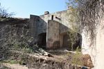
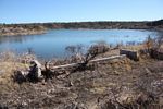
Today, the Diversion Dam sits pretty much intact. Time is taking its toll on the Power Canal. In its upper reaches, upstream from the School House Boat Ramp, there are long stretches of the Canal that are worth visiting. Many of the hard structures still remain. The same cannot be said for the canal below mile 7. It, along with many of its features have been damaged or destroyed by the encroachment of the waters from Roosevelt Lake.
The Dam and the Power Canal are readily accessible. I recommend checking them out.
| Trips |
| Home |